On the bus…
While Cora’s on the bus, let’s learn a bit more about the geography of Cuba, especially its neighbours.
Let’s look at an extract from a book about cuban geography
Cuba is an island in the Caribbean Sea.
Actually, it’s the biggest island in the Caribbean. It is only 90 nautical miles from Florida in the United States and 128 nautical miles from Cancun in Mexico.
The island of Cuba is long and has lots of little islands surrounding it, which belong to Cuba.
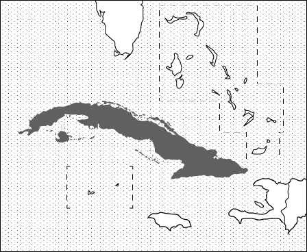
This is a map of Cuba and its neighbours. Except it’s blank.
Can you label the countries around Cuba to help Cora?
Use the blank map of page X of the worksheets.
Can you label the islands that surround Cuba using the cardinal and ordinal directions?
To the North are the United States
To the North-East are the Bahamas
To the East is Haiti
To the South-East is Jamaica
To the South are the Cayman Islands
Wait, there’s a message from Noah!
Activity 2: Making
a map of Cuba
Can you help Cora fill in the map of Cuba?
On page x of the worksheets, you’ll find a mostly blank map of Cuba. In this activity, you’ll fill in different features on the map. You’ll need to do some research by looking at another map of Cuba.
Maybe you have an atlas with a map of Cuba? Or you can find a map online.
You’ll need some pens or pencils in different colours to complete this activity (black, blue, purple, yellow or orange)

Take a BLACK pencil and label the capital city of Cuba. It’s the largest dot on the map, but do you know the name of the capital?
There are plenty of other cities around Cuba. There are spaces to label the cities on the map with the first letter of the name already written down. Can you label the rest of the cities? There are X cities. Do this with a BLACK pencil.
The cities are:
Take a BLUE pencil and label the sea which surrounds Cuba
The Caribbean Sea
Take your BLUE pencil again and label,
The Florida Straits
The Straits are between Cuba and the United States.
Cuba has lots of islands, far too many to label them all.
Find the largest island that belongs to Cuba (but not the main island itself!).
It’s called Isla de la Juventud. Label it with a YELLOW pencil.
Let’s label 2 mountain ranges in Cuba. Mountain ranges are labelled with cross hatching. Label the following mountain ranges:
The Escambray Mountains
The Sierra Maestra
The highest mountain in Cuba is called the Pico Turquino and is labelled with a small triangle. When you label mountains on maps, it’s normal to also write down how high the mountain is.
How high is the Pico Turquino? Write it on the map next to where you write the name.
Near the town of Guantanamo Bay there’s a little area which is blacked out. This bit of land is a funny place. Although it is owned by Cuba, it is currently being rented by the American Government, even though the Americans and Cubans don’t like each other much.
It is called Guantanamo Bay. We’ll talk a bit about it later. Label Guantanamo Bay with your RED pencil.

To the south of Havana and Matanzas there’s a hook of land. Colour this hook in with your GREEN pencil and label it as the ZAPATA SWAMP.
Lots of animals live here, including Caribbean flamingos (you can draw a flamingo if you like).
The map is done! If you want to add more drawings you can. Some typically Cuban things you might want to add are:
Cigars
Musical instruments like a guitar or trumpet
Fruits like bananas or papayas